
In the end, this will probably look like zipline review pages.
It isn't meant to be, though.
What the trip was supposed to be was another 'back to normal life again' vacation.
It's a bit strange that I took the first one of these more than a year ago.
Back then, the two-month Corona lockdown had just ended and hotels had opened again, so it seemed right to celebrate the end of the arbitrary restrictions by traveling again.
Even though it was only within Germany and for a weekend.
But things were going to get better.
At least a bit.
Except for the tiny bit of lockdown in autumn ("Only a wave-breaker lockdown. It'll be no more than a month. We need to have it, so all will be over by Christmas and family can celebrate together".)
But then, of course, they couldn't.
The lockdown got extended. ("Only for the Christmas days. Celebrating together is much too dangerous.")
And then extended again. ("New year's celebrations? But that's people from different families meeting. They will get drunk. They might even hug each other. Way too dangerous!")
That was, of course, followed by another lockdown extension ("Because otherwise people will have winter vacations. That's how the whole thing started last year!")
After that, vaccines got available and the travel period was over, so, naturally, the lockdown got extended even more. (At that point, there weren't even excuses anymore.)
Then, there was another extension, as Easter holidays were too dangerous to do.
Followed by another lockdown, to cover the Pentecostal vacations as well.
(And it wasn't simply extensions. Things got more restrictive as well, with "Emergency Break Lockdown" rules, people being forbidden to leave their states and, ultimately, being forbidden to travel more than 15 km from their homes.)
At least I have a job that can be (reasonably) done from home, so it didn't matter much that we had mandatory 'home office' for more than a year.
But that was supposed to end at the end of August and I'd be back in my office starting September, 1st.
So I got the idea to start where I left of. Or where I would have been a year earlier.
The last thing I did before being sent home from the office, back in February 2020, was a business trip to Rome.
At that time, I had noticed that there's an interesting zipline (kind of) near Rome and another pair of ziplines a bit farther away (I didn't pay too much attention to where it really was - turned out to be quite a bit farther away.)
But the tourist season hadn't started yet, so both ziplines didn't run in February,
No problem. There was another project meeting in Rome scheduled in June 2020 and I would combine that with a couple of days of vacations and drive to those ziplines.
Except...
The meeting was cancelled and I didn't get to go to Rome (or Italy) at all.
So when it was scheduled that I would be back in the office in September, it seemed like a fun idea to go to Italy on the last days of August, visit the ziplines and then go back to the office and work normally, like I would have when I returned from Italy roughly 18 months earlier.
It didn't happen that way.
Working from home office was extended to March 2022 (more than two years after it started), so there was no 'going back to normal' after the trip. (Technically I could go and work in the office, but current regulations make it a bit pointless, as only one person per room is allowed. So I'd get all the disadvantages of office work (travelling to work every day, wearing a mask every time I move around outside my room) without any of the advantages of office work (like being able to talk to people and getting quick feedback).)
But home office or not, going to Italy for ziplining still was a good idea.
The first one was at Rocca Massima, a bit south of Rome.
I was staying in Castle Gandolfo (no, I wasn't staying in a castle - that is the name of the village) and drove down from there.
(The picture shows neither the place I was staying in, nor the castle - it's simply the local train station.)
Rocco Massima is one of these strange mountain villages, which I never quite understand. They are picturesque and located on some rocky precipice. But even with a car, they are hard to reach. The roads are small and serpentine and you can't see what's coming around the next corner. And it's hard enough to squeeze by if there's a car coming the other way. But usually, it's a bus that's heading towards you...
So why people decided to settle there, instead, well, in the valleys below, is something I don't understand. Yes, the view is nice, but it would presumably be enough to walk up there once per weekend, enjoy the view, and then go back to easier grounds for the rest of the week.
Put for whatever reason they put their villages up the hill, they look photogenic.
But I wasn't there for the view, but more for the drop.
The zipline there is supposedly the fastest and longest in the world.
But then, many of them are.
On a list of the longest ziplines in the world, it doesn't even make the top five.
The claims about 'fastest', 'longest', 'steepest' are often based on special pleading, as well as misleading phrasing.
It reminds me a bit of a passage by Bill Bryson, where he describes the Manson crater as the "largest and most perfectly preserved impact crater in the mainland United States".
Which is, technically, true.
But the statement benefits a lot from that, commonly, 'and' is read as 'plus', so it raises the impression that the crater is the largest, as well as the most perfectly preserved crater, which also happens to be in the mainland United States. But, of course, it's a logical 'and', so of those craters that are in the mainland US and are perfectly preserved, it happens to be the largest one. But that conveniently excludes all the larger craters which are offshore or deformed.
I am not sure how the zipline at Rocca Massima justifies its claim of being longest and fastest in the world.
The English text on their page is somewhat contradictory at points, which is likely due to translation artefacts. (For example, they give the speed of the ride as "a peak that is close to 160 km/h", but also mentioning that people are "darting at full speed failing to exceed 150 km/h.", with a further mention of "Full speed 160 km/h".
Possibly the original Italian text makes more sense, but I don't read Italian, so I don't know.
It looks though as if an automatic translation of the Italian web page makes more sense than the English text given on their page. The automatic translation mentions "a maximum peak approaching 172 km/h" and "reaching speeds of over 150 km/h". Which makes more sense, assuming that their speed record is almost 172 km/h (presumably with special clothing, new and freshly oiled runners on the cable and a bit of wind from the back) and speeds of normal customers can be around the 150 km/h mark.
As far as I can tell, it was the longest and fastest zipline when it opened, but other ziplines have opened since.
On the other hand, there's a zipline in Wales that claims it's the fastest zip line in the world and the longest in Europe. And that's almost 700 meters shorter than the one in Rocca Massima in Italy. (But maybe, due to Brexit, people in Wales got a bit confused about the fact that Italy is located in Europe.)
In any case, it doesn't matter.
I didn't travel to Italy because this was the longest or fastest zipline, so it didn't matter much how accurate the claim about speed and length (still) are.
The starting place is right next to a small local church (probably a chapel, not a church).

This panorama is from a viewpoint near their ticket office. The church/chapel is to the right, the shed with the harnesses for the 'flight' is the building with the red roof, near the flags. The start of the cable is to the left of it, while the start of the ride is a on the metal platform a few meters below.
The endpoint of the cable is in valley, destination, slightly over to the right. Even on site it's hard to make out from the starting point (whether it's the longest zipline or not - it is a long way to go...), so I marked it with a red circle in the next image.

After going to the ticket office, getting weighted and collecting my 'flight ticket', I went to the starting point and got my 'flight gear'.
All the ziplines I did on the trip were 'falcon style', which means that you (f)lie face down, arms tucked in to the sides, and legs stretched out.

That makes of a fast ride and, more important for the organizers, a more predictable one.
If you have a zipline where people 'sit' in the harness (or, in rare cases, hang upside down), the speed will vary significantly, depending on body shapes, how customers turn into the wind, whether they spread the arms wide or keep them close to the body, whether they let the legs hang down or whether they pull them up.
If customers are lying down straight, then the speed of the ride depends almost exclusively on the weight.
Of course, wind speed and direction still are in influence, but the speed of the ride is predictable, as they attach a little 'sail' to the harness (the size of the sail depending on the weight), so there's not too much variance in the speed of the 'fliers'.
So the risk of someone not making it to the other end due to too much air resistance or too little weight is reduced. And so is the risk that someone heavy will arrive at the braking mechanism at high speed.
But it restricts the 'sightseeing' on the way a fair bit, as you are looking straight down, with maybe a sneak peek to the left and right for a second.
The 'flight' itself is indeed fast.
I had some headwind, especially on the second 'flight', but still managed reach a top speed of 133 km/h (on both flights, which is an indication that they are quite good at picking the right 'sail').
The average speed on the first 'flight' was 95 km/h, on the second 89 km/h. (That both had the same top speed is because the first bit was protected from the wind, so the top speed was unaffected by this, but once I came out of the 'wind shadow' of the mountain, the wind hit me in the face strongly and slowed my down on the rest of the ride. (I checked the times it took me to cover the first 700 meters of the cable and they were almost identical.)
The effect of the wind can be seen on the GPS trails of the two 'flights'. On the first one, in cyan, the line directly connects the start and the end point, while on the second 'flight' (the yellow line), the cable is blown a bit further to the east (by about 30 meters in the middle).

The view along the way is down on trees.


There are some houses and roads along the cable path, but mostly there's trees.


I am a bit unsure about the height above the ground.
Their web site claims a maximum height of 310 meters above the ground, but that seems unlikely, given that it's a height difference of 350 meters between the start and the end point.
So there would either need to be a deep valley somewhere along the way, or the landscape would need to drop dramatically on the first few hundred meters.
According to the top map and also from looking at the cable from the side of the road when driving back, the profile of the ground looked similar to the curve of the cable above, so sudden deep dips looked unlikely.
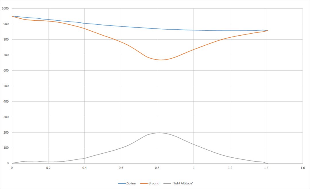
And suddenly it's two hours later...
After I wrote the line above, I wondered whether there might be a way to find the (approximate) maximum 'flying height' and started looking into web services that would give me the elevation at a given coordinate, so I could correlate the GPS data from the 'flight' with the profile of the ground below.
It turns out that there is such a service, which is free, has decent data resolution and is easy to use.
So I got distracted and wrote a tool to read in the GPS data from a zipline 'flight' and calculate the height over the ground...

Checking the GPS data and the ground profile, it turns out that the shape is, indeed, not that different, so the altitude remains nearly constant for about 2/3 of the way. And that the highest altitude above the ground is at approximately 120 meters.
Although making the picture look right took another short round of coding. When I took the GPS points and plotted the profile of the ground below, it looked a bit skewed and not like I remembered it. I then realized that the GPS points had been stored (roughly) a second apart, but as my speed was changing significantly (like, let's say accelerating to 133 km/h and slowing down to about 40 km/h when I reached the braking device at the end of the cable), the points weren't all equidistant and that distorted the profile. After I used the distance travelled as the x-axis, instead of the time, the profile looked right.
In any case, I was never more than 120 meters above the ground.
Which is a 'comforting' height. You don't notice the speed much.
It would have been cool if the landscape had some small hill somewhere along the way, reaching up almost to the cable - it would have been exciting to 'fly', for example, 10 meters above the ground while going more than 100 km/h.
At 100 meters above the ground, you don't feel like you're going fast.
A bit like looking sideways out of a train. If there's a forest by the side of the track, you see the trees zipping by and it feels fast. If there's a meadow and some trees a hundred meter away, it's almost idyllic.
Almost too idyllic.
On the second run, when the wind had picked up, I felt slowing down towards the end and started to worry whether there might be too much headwind and I would come to a standstill somewhere along the cable, as I wouldn't have enough momentum to reach the end of the line.
The GPS shows that I was still going at more than 35 km/h when I hit the braking system at the end of the track. I was presumably still going at 60 km/h or more when I had the feeling that I was close to coming to a stand-still.
The perception of speed on a zipline is obviously not too reliable. (At least unless you're doing it way more often than I do.)
In any case - it was a fun ride. I like ziplines!
Although I got a bit unlucky with the overall timing. They have a mini-bus to take customers back from the arrival point to the starting point. And they only run that when there they pick up a full load, which is about once per hour.
So on the first run, I was the fourth person to zip and on the second run the first one.
So I had to wait 40 minutes after the first and 60 minutes after the second run, before the bus brought me back to the start.
Not too bad, as it wasn't too hot, but a somewhat wasted opportunity.
There is a little building near the waiting area and it looks a bit like a bar.
It would have been good to be able to buy something to drink there, have a snack or an ice-cream. But the place was deserted, so there wasn't much to do during the wait time.
At least you can watch people coming down the zipline.

And some cactus plants.

And look back to the starting point, up on the hill.

As the image shows, the weather wasn't picture-perfect, with a lot more dark clouds than blue skies. I didn't mind that, though. After all, it was August, the middle of the day and in the middle of Italy, so on a sunny day, it would have been unpleasantly hot. With the cloud cover, it was warm and dry and comfortable.
After that, I drove back down the serpentine road (much slower than zipping down...) and to Lake Albano, as I was staying in a hotel near the lake.
To do something even slower than ziplining and driving, I did a short boat tour on the lake.


At sunrise next morning, it was a bit foggy on the other side of the lake, which made for some nice views of silhouetted trees.


After sunrise and breakfast, the day was spent driving, as the pair of ziplines I wanted to visit was about 400 km south-east of Rome.
I stayed in a hotel near the highway an, on the following day, drove the last 30 km or so to Castelmezzano.

The set-up sounds simple and clever.
Instead of having one zipline, they have two.
One going from the village Castelmezzano to the village Pietrapertosa. And one going the other way.
On paper, that makes things easy to handle.
You let people zip over to the other side. And then attach them to the other cable and let them zip back again.
You need almost no infrastructure on the remote site. And it is simple to get all the equipment (and customers) back to where they started from.
Of course, you still have to provide some sort of shuttle service for people and gear. After all, the ziplines go down about 125 meters each (actually 128 and 115 meters), so you end up roughly 250 meters lower than where you started.
Customers might be willing to walk 250 meters uphill, but they'll probably grumble. And you need at least some sort of transport to get all the gear back up again. So you might as well operate a shuttle bus. At least you're not that far from where you started from, so it's a short uphill ride. (In comparison, the bus ride back from the end of the zipline in Rocca Massima to the beginning is about 8 km of distance and takes about 15 minutes.)
Hence this should be easy to do:
But, of course, that's not how it's done.
The ziplines are set up at some distance from each other (direct distance between the endpoint of one zipline and the beginning of another is 700 meter direct distance and about 2 km travel distance) and there's no shuttle service going all the way to the starting point (but independently where you are planning to end up, you can always finish with a bus ride).
The actual procedure is this (when starting in Castelmezzano):

The pink trail is the bus shuttle to where you start walking to the Castelmezzano zipline start, the red parts are the walking sections, the white lines are the ziplines, the green trail is the shuttle bus from the Pietrapertosa zipline end to the village of Pietrapertosa. And the cyan trail is the bus shuttle back to Castelmezzano.
It all seems a bit more complicated than it should be. But it is a good idea. (Well, except for the uphill walking parts...)
Part of the reason for the way it is organized may lie in the villages themselves.
As it is, both villages are 'equal' regarding the ziplines. You can start at either village. And tourists get to visit both villages. (The way that I would have done it, even if the zipline switchover would be in one of the villages, instead of some random point in the mountains, it would simply be a turn-around-point and, essentially, irrelevant.)
I don't know how the ziplines were financed. If it was a private company, then it presumably wouldn't matter much. (Probably nobody cared much where the other end of the Rocca Massima zipline was placed.) But if there was some government funding for supporting tourism was involved, then having 'equal standing' of the two villages might have been an important factor.
While I didn't manage to go to it, there's a suspension footbridge (or Nepalese bridge, as they call it) down in the valley between both villages. And from this bridge, there are two via ferratas (or is that via ferrati?), one going towards Pietrapertosa and the other going towards Castelmezzano. Both approximately the same length (1731 meters and 1778 meters with the paths to and from the via ferratas and the via ferratas itself 992 and 862 meters long), the same difficulty (easy), as well as roughly the same altitude to climb (249 meters and 331 meters). The numbers look as similar as they can be made, given the terrain, so it looks like there is some rule of 'equal standing' between the villages in effect.
Whatever the reason, the two ziplines run at some distance from each other. And this makes them nicely different.
Not so much in regard to the technical data. Both are about 1.4 km long, both have an altitude difference between start and stop of roughly 120 meters, both have a max speed of a bit more than 100 km/h and an average speed around 80 km/h. Both are 'falcon style' rides, where you lie face down in the harness.
But there's a rocky ridge between the two zipline. And that makes for two different experiences.
The zipline between Castelmezzano and Pietrapertosa is the 'nature' zipline, while the one going from Pietrapertosa to Castelmezzano is more the 'sightseeing' zipline.
Let's start at Castelmezzano.
A bus goes up towards the starting point of a footpath.
From there, it's a fair amount of walking towards the start of the zipline. Starting with a short ascend (to about 60 meters higher), then half a kilometer that's flat. Then 30 meters down again and 60 meters up, before reaching the zipline.
The path is nice, wide and well maintained, so the only issue with walking is that most of it is upward. Which (kind of) separates the visitors who live in mountainous terrain from tourists (like me) who live in places that are, essentially, flat, and pretty much out of breath when they reach the top.
(The path needs to be wide and well maintained, as they are using a large quad to bring all the equipment to the zipline. There are some ziplines where customers are equipped with all their gear before going to the zipline, which requires walking in the harness, wearing the helmet and carrying the 'cable roller', that goes on top of the cable, in the hand. Those outfits hardly need any infrastructure at the higher end of the zipline, but it also means that customers need to carry all the stuff themselves. At Castelmezzano there's a fair bit of uphill walking, but customers only need to get themselves uphill. The necessary gear is provided at the top.)
Fortunately, there are nice views along the way, so you can always stop to 'admire the view and take a few pictures' while you stand there and gasp for air. (Though it's unlikely to fool anyone...)


The second image above also shows the final ascent towards the zipline start, so from where I'm standing, it's still a bit of a walk.
Up there everyone gets outfitted and ready to get onto the starting platform.


The zipline ride from Castelmezzano towards Pietrapertosa is the most breath-taking of those I did on this vacation.
It starts deceivingly shallow, running only about 10 to 20 meters above the ground. So at first, it feels a bit like those ziplines at playgrounds or at climbing parks.

Note: The cable visible at the right side isn't the zipline. It's a cable running next to the zipline that has large red and white spheres on it and serves as an indication to airplanes and helicopters where the zipline is. Why that is a good idea became, unfortunately, apparent in 2018 when a helicopter flew into a zipline in the United Arab Emirates (not surprisingly also called "world's longest zip line") and four people were killed.
Then, for a short moment, the ground is even closer, as you run over a rocky peak.

And then you cross the cliff and the ground falls away below you. And you are suddenly high above the valley.


Over the deepest part of the valley, the ground is about 300 meters below you.
So I had the same kind of view I had from the zeppelin I flew with the previous year, which was operating at a similar altitude. At roughly the same speed.
The feeling of altitude (or depth below) was enhanced by the street going down in serpentines on one side of the hill and climbing up on the other. It provided a clearer perspective and gave the valley more 'shape' than the forest below would have done.
The end of the line was located at a somewhat unusual point for a zipline - at the crest of a hill (usually it's more likely to be down in a valley somewhere),

Arriving in Pietrapertosa, there's a wooden hut, where you return your gear, before you walk up a few steps and wait for the bus.

You can also purchase a picture of your 'flight' there. But that looks surprisingly tame compared to the ride itself, as it gives almost no indication of the length of the zipline or the heights. According to the picture, it might also be a 200 meter zipline 20 meters above the trees.


But it's nice to have a souvenir or two.

And, again, you can use the time you wait for a bus to look back towards the start and people arriving. (It looks a bit odd, though, in this picture. The braking system is towards the right of the image (where the blue platform is) and someone is arriving there. What looks a bit like someone with a red helmet, a white shirt and spread arms near the middle of the picture is, in fact, one of the red spheres that serve as an aircraft warning, with a section of the street passing behind it.)
This is the profile of the zipline and the ground below:

The bus then brings you from the end of the zipline to the entrance of the town of Pietrapertosa. It's only 1.2 km distanced, but it's roughly a hundred meters uphill, so the ride is appreciated.
The bus doesn't bring you to the zipline, though.
As is the case in many old Italian towns (especially those on hillsides), the streets in Pietrapertosa aren't wide, so the bus drops you near the entrance to the town.
The image below is from Castelmezzano and not from Pietrapertosa, but it illustrates the point.

Again, there is a short walk from the bus stop to the place where you collect another harness.
Though it's easier on this section. It's a ten-minute walk and it's only 38 meters up.
Along the way is also a minor local attraction - a natural rock that looks a bit like a man's head. (Kind of. More like one of the orcs from Lord of the Rings.)

It's not that impressive, but it is a convenient excuse to stop and catch your breath.
From the 'harness hut' it's a short walk (downhill this time) to the start of the zipline.

The view along the zipline differs distinctly from the zipline going the other way.

While Castelmezzano to Pietrapertosa is almost entirely over forested mountainsides, with a few roads going across for perspective, the other direction is more varied.
The town of Castelmezzano can be seen ahead (in the other direction, Pietrapertosa is hidden by the mountain). The ground is a mixture of forests, open spaces and bare rocks.


Near the halfway point, there's a view of another local attraction - the 'Nepalese bridge' (suspension bridge) connecting two 'Via Ferrata' climbing trails, which go along the rock faces.

The suspension bridge is the small, straight line, visible at the lower edge of the image, slightly to the right side.
From there, the zipline continues to a place a bit outside and above Castelmezzano.

The end of the zipline is a bit unspectacular (especially after the views along the way).
The zipline runs close to someone's garden wall and then ends up (kind of) in somebody's backyard.

Even though doesn't look much, at least it feels dramatic. After spending most of the 'flight' high above the ground, you lose the sense of proportion a bit. And looking straight down during the final section, it feels like you are about to slam into the ground any second. Of course, you are still a meter or two above the ground, but at that point it feels like you're barely ten or twenty centimeters over the grass.
Nice finish.
The zipline from Pietrapertosa is a bit closer to the ground than the other one (maximum altitude around 200 meters instead of 300 meters), but in most other respects (length, steepness, speed) not that different.
After that it's a very short bus ride back down to Castelmezzano. This last bit is less than a kilometer and downhill, so if the bus takes a while to arrive, it's probably faster to walk the final part to Castelmezzano.
At least if you are done for the day.
The bus from Castelmezzano stops at the zipline arrival point when going up to the Castelmezzano starting point (specifically, to the point from where you need to walk there). So if you want to ride the ziplines more than once, it's better to hop on the bus as it's going uphill, instead of taking the bus down to Castelmezzano and then use it the next time it's heading towards the start.
As I went a long way to ride the ziplines at Castelmezzano and Pietrapertosa, I did a second round on them before heading back to Castelmezzano.
Then it was time to drive back to the next 'proper' town (i.e. one that had a hotel instead of only guest houses) and spend the night there.
Next day I had to drive back towards Rome, as I needed to catch my flight home.
While driving down from Rome to Castelmezzano was without problems, there were a large number of traffic jams on the way back north, so it was slow going and long periods of stop-and-go.
To make up for that, I drove to a go-kart place not far from the airport and did a couple of laps there, to do a bit of driving where I had the foot more on the throttle than on the brakes. (And partly, even though this is catering to stereotypes, to drive a bit like everyone else around me seemed to be driving on the highway...)


In any case, a nice bit of fun before going home after this short vacation.