 looking train signal")
That morning I also said good-bye to the somewhat sinister looking train signals in Jokkmokk and took the bus heading south.
While not the stuff of a Charles Dickens story, it was a bit like going from present day dogsledding to the ghost of dogsledding past.
I visited Catte and Kenneth, who used to have a dogsledding company, with which I've been dogsledding for six years, before they closed their business and started a bakery.
But they still have their guest houses, and that's where I was staying for the next couple of days.
I've also joined up with Constanze again. We had been together on a number of dog sledding trips in Canada, Finland and Sweden, but she didn't want to go on this year's tour, so we decided to meet after the end of it, with her spending a couple of days cross-country skiing before I traveled to Umnäs.
So I joined her doing cross-country skiing.
This time for fun.
Initially I had asked Catte to help me to learn cross-country skiing, as I had assumed that I might need it on my trip to Greenland (which happened last year).
I've written about that trip at some length here.
But the short version is that, a long time ago, the tourist office in Qaanaaq, Greenland offered a trip where you could stay in a house of the abandoned settlement of Qeqertarssuaq on an island across the fjord from Qaanaaq.
They would bring your gear over by dogsled, snowmobile or car, so you could ski over to Qeqertarssuaq with only a daypack, everything else being already there. Then stay there for a couple of days and ski back (and someone would bring your luggage back for you).
That sounded like something interesting to do, but before I committed to that, I needed to be sure that I would be able to travel 22 km across a frozen fjord on skis.
Ultimately, the trip to northern Greenland ended up being completely different and not involving skis at all, but I didn't know that two years ago. It was still worthwhile doing it, because without the confidence that I could go 22 km on skis, I wouldn't have started to ask about the possibility of doing an iceberg photographing trip to Qaanaaq. And I wouldn't have done the trip I did.
When I visited Catte and Kenneth last year, that was still before the trip to Greenland. I knew by then that I wouldn't need to ski in Greenland, but it still seemed a good idea to be prepared. (Also, there was still a bit of an open issue. Catte's ambition had been that after a week of teaching me skiing, I should be able to go skijoring, i.e., standing on skis and being pulled along by a dog. I definitely hadn't been ready to do that after that week in 2022. But it still was (sort of) on Catte's "to do" list. In the end, I was standing on skis and being pulled along by a dog last year. It wasn't quite as expected, but it did happen. So that was checked off the list.)
This time there wasn't any Greenland trip to prepare for. And I didn't have to be skijoring.
All the cross-country skiing this time was done for fun only.
And for playing around with my drone.
I had tried to take some dogsledding photos with a drone. But I didn't have much practice and had some problems to control the drone and drive a dogsled at the same time.
It seemed a better idea to try some things with the drone while cross-country skiing, as it is a bit easier (at least in theory) to control a drone when you are standing somewhere on skis. As opposed to standing on a moving sled, trying to use the controller while still holding on to the sled.
There are also a couple of automatic modes and movements the drone has. And if you don't know what you're doing (or the drone will do), it's best to test them when you are standing in the middle of a frozen lake somewhere, with nothing that the drone can crash into. (And, in case the drone goes down unexpectedly, be able to see where it is.)
The most convenient place for cross-country skiing around Umnäs is the trail next to Slussfors.
Well, that's not quite true. The most convenient option is to simply go across the street and ski on the local forest trails. Or walk down to the church and ski on the lake.
Slussfors, however, has a properly prepared and maintained loipe.
And that also includes a beautiful beginner's trail. It's only 2.1 km long, but winds in a pleasant curving trail through a forest. It's fun to do, has straight and curvy bits and is flat, with no tricky climbs or scary downhills. And it's only a few kilometers from Umnäs, so it's a short drive to get there.

And the trees are sufficiently far apart to fly a drone without hitting anything.


A 2 km round trail is also a convenient length. Depending on mood, energy and weather, you can do it multiple times.
It's nice enough that it doesn't get boring and you never commit to more than 2 km at a time. So it's not like heading out for kilometer after kilometer, knowing that you also need to go back all the way. (This was a bit of an issue with the trails in the forest at Umnäs. The trails are nice enough, but they are mostly straight and get a bit same-y after a while. And then you need to go back the same way. We didn't manage to find a way to do a loop there. Actually, we had planned to do that one afternoon, but it started raining and since the loop we had planned was roughly 12 km long (assuming that it was possible to do it), it didn't seem worth doing in the rain, so we only did a bit of skiing on the lake in the morning.)
We returned to the Slussfors trail later and did another few laps on the beginner's trail.
Constanze also gave the regular trail a try, which is also a looped trail, but a bit longer and with more ascents and descents. I preferred to skip that and went to the barbecue pit and made a fire instead.
When we went out on the lake, that was mostly to try a couple of drone preset flight paths.

Conditions on the lake weren't good, with slushy snow and a couple of wet spots on the surface. So we went only out far enough to give the drone some room to fly, but didn't even attempt to cross the lake.
In the afternoon we did some minor skiing to watch Catte and Kenneth riding their horses.
Since they stopped doing dogsledding tours and don't have to take care of more than 50 dogs, they spend a lot more time with horses. They already had horses while they ran their dogsledding business, but now they are taking the riding much more seriously, including going to competitions.
To enable them to do some riding and training in winter, they had cleared an oval track in a forest clearing.
So Constanze and I went there on skis to watch them and their horses.


Then it was time to ski back to the guest houses.
What became apparent was that I'm not any good at skiing.
I'm not moving elegantly or even smoothly. In fact, I look more like Chaplin's "Tramp" character when skiing. (Although the wide snowmobile trousers I'm wearing intensify that impression.)

The picture also highlights why it's not that exciting to ski in that forest - it's one long straight lane through the forest, without much change or distraction.
Next day the weather was a bit better, so we went to the cross-country skiing trail at Tärnaby.
A minor downside is that it's not a loop. You start from the parking spot and continue until you feel you've skied halfway enough. Then you turn around and ski back again.
But the trail is good and there are lots of good views and interesting bits, with some ups and downs. For most of the trail, they are descents I should be able to handle. Usually I'm not and I fall, but they are still easy enough that a fall is embarrassing, but not painful. So they are worth giving it a try anyway. And sometimes I make it to the end of a downhill section with the skis still on the ground.

That wouldn't work for the final section of the trail, but we never went that far.
The trail ends up in Tärnaby and (assuming you arrange some transport) you can start at the parking spot at the beginning and ski all the way down to Tärnaby. The final part, however, has a steep downhill section. You are advised to turn around before reaching this, if you want to go back to your car. And only go on, if you want to do the trail as a one-way trip. (Also, you shouldn't go on the last section if you can't ski properly, but that's not an issue for anyone in northern Sweden.)
Something I liked about the track (and the trust in people wanting to use it) is that the light switch for it is publicly accessible.

The final part (which can also be done from Tärnaby as part of a shorter or larger loop) can be illuminated.
And instead of turning the lights on every night, they simply have a light switch.
So if you want to go on the trail and it's getting dark, you can switch the light on yourself.
However, when we went to the track, it was during the day, so that didn't matter. We also only used the upper part of the trail, so there weren't any lights there anyway.
This time Catte joined us when we went skiing.


Weather started out nicely, with even a bit of sun. And even though it was overcast when we got back to the car, it wasn't bad (no rain or anything) and the snow and the tracks remained in good conditions.
We had a bit of a hectic moment, though, when I thought it would be a good idea to ski down a minor slope with the drone following me. (And in case you look at the following pictures and think "What slope? I can't see any slope. It all looks flat to me!", you're mostly right. I really can't ski properly, so even that minor gradient is something that presents me with problems.)
The idea with the drone was that it was a downwards slope with an S-shape that I might barely be able to do. So with a drone following me, that would be either some nice swooping tracking shot or, more likely, some funny fall. (And if the fall would have been serious, at least it would be well documented.)
So I gave the drone controller to Constanze (who had about five minutes of drone flying experience so far) and asked her to fly the drone behind me (preferably not flying the drone into me).
Which worked for about ten seconds.

But then the 'S' shaped section followed and I was going around some trees.

And Constanze did trust her ability to fly along the path behind me without hitting any tree. So she tried to fly above the trees, but lost me out of sight when she was doing that.
When I was back in frame, she didn't notice me. I had fallen down when I tried to do the second curve of the 'S' and tried to get up again. I did find a frame where I'm visible trying to get up again, but Constanze was rotating the drone, which was looking at some snowmobiles passing by, so I was only in frame for half a second.

By then, Constanze had lost sight of the drone, so she didn't know where it was.
To avoid the risk of hitting a tree somewhere and having the drone crash at some unknown location, she sent the drone flying upwards, way above any trees.

She then handed the controller to Catte, who followed me on skis. (In the meantime, I had managed to get back up again and ski down the rest of that section, assuming the drone being right behind me, even though I couldn't hear it.)
Catte came up with the controller and I tried to figure out where the drone was.
I did try to swivel the camera up and down a bit and rotate the drone, trying to spot the trail and, possibly, us on it. Keenly aware that the battery would be empty in a few minutes.

In retrospect, I had kind of looked in the right direction. But the controller has only a 5.5 inch screen, and we were, essentially just a pixel on it. Even on the screenshot above it's hard to tell where we are. (There's a white area towards the lower right of the image above. And there's a black spot in that area. That's Catte and I standing there, staring at the controller, trying to figure out what the drone is looking at and where it might be.)
In the end we decided to give the automatic 'return to home' option a try and hoped that this wouldn't send the drone into a tree.
Additionally, we weren't quite sure where the 'home point' had been set and where the drone would be flying to.
During the return flight, there was one shot that gave an overview of the situation, but we didn't recognize it at the time

The place where I started from is at the middle of the lower edge of that image. I then went right around the group of trees on the lower right, when the drone lost sight of me. I then tried to turn left again (nearly at the right edge of the image), where I fell. Then I got up again and skied the last part, which was mostly straight. That is where Catte caught up with me (we're still visible as two distinct black spots in the clearing on the upper right). In the meantime, Constanze had followed us and was in the middle of the straight section toward us (visible to the left of the round tree cluster on the right of the frame).
The drone, however, kept flying and started to look down, so soon there was only white snow visible, which didn't really help to localize it.
But the camera started to look straight out again and, lucky for us, showed us the only thing in the vicinity that we did recognize and know where it was - a trail distance marker. There's a marker about every kilometer on the trail, showing how far you've come from the parking lot. And when we started flying the drone, we were standing right next to one. So we now knew exactly where the drone was.

As Catte was by far the fastest on skis, she went back along the trail to collect the drone.
She wasn't quite the first to reach it, though.
Someone was skijoring along the trail and presumably he and the dog were a bit surprised to have a drone hovering close to the ground, right next to the trail. (I didn't know that it was hovering there. I never had used 'return to home' before and assumed that the drone had landed at the home location and shut the rotors off. I wasn't aware that it went to the location, but kept flying.)

Giving the drone only a sideways glance, the continued along the track.
A moment later Catte reached the drone and was able to grab it.
So everything ended up being fine, with nobody hurt and the drone retrieved and intact. But it had been somewhat intense twenty minutes.
And that's nearly it.
We went back to Umnäs (safely avoiding two moose, which were standing on the road), spent one more night at the guest cabins and then drove to Hemavan to fly down to Stockholm. (While driving to Hemavan the next day, we encountered another three moose, crossing the street.)
Happily, I got a dog with me in the cabin again.
When there were still about 50 dogs around, I used to ask for a 'house dog' for the days I was staying in Umnäs.
Somehow, if there's a place with a wood burning stove, it 'feels right' to have a dog in front of it. It somehow feels proper.
As, without the dogsledding business, Kenneth and Catte only have four dogs left, I hadn't asked to borrow one last year (even though all four of them are now real 'house dogs'). This year, Kenneth asked whether I would like to have a dog in the cabin again, so I got Sting to share accommodation with.

Technically it wasn't necessary to go out with the dog at night. Having a quick round outside before going to bed is sufficient for not having to go out again until morning. But it was kind of interesting to get up around 2 am, get dressed, grab a headlamp and hike into the forest for a bit. Not something I would like to do every night, but doing that twice or thrice is fun and Sting didn't mind.
And presumably Sting liked to sit or lie in front of the fire.

I assume Sting also enjoyed having a bit of peace and quiet for once.
Among the other three dogs he is usually around with, Ladun is similar to Sting in look and behavior, but Dromeo and Hercules are much younger and a lot more energetic. So Sting might enjoy having an evening without other dogs running around (and over him) all the time.
At least, that's what I presume. But then, the direction Sting is looking is also the direction of the main building. Maybe Sting is sitting there, listening to the sounds from over there and wishing he would be with the other dogs. Who knows? Still - nice to have a dog in the cabin!
The flight down to Stockholm was as usual, except that the airline flying Hemavan to Stockholm had another name again. It used to be Amapola Flyg, but they changed their name to populAir recently. It still was the same company, though. While they had relabeled their planes on the outside, some of the designs on the inside still showed the Amapola name.
Usually there's not much to write about the airport in Stockholm (Arlanda), but this time, there were some new things (and an old one I finally noticed).
They had restructured their security controls and moved them from the airfield side of the terminal over to the other side. While that meant a somewhat longer walk from security to the gate (and a lot more stores - it's like having to walk through a mall first before it looks like an airport again), it means that they have upgraded their X-ray scanners and it's no longer necessary to remove laptops or fluids from your luggage or even to put stuff on different trays. You can now put your jacket on the tray, put the hand luggage on top of it and that's it. Almost as convenient again as it was forty years ago.
I also liked a bench in the departure area, which looked like a baggage transport belt, complete with luggage shaped cushions.

Unfortunately, it's a one-of-a-kind art object and not the general design for the benches in the airport (which would be great!), but it is a proper bench and you can sit on it if you want to.
One thing in the airport that I had vaguely known about for years, but never really looked for or found, was Jupiter.
All over the world there are miniature solar systems or "planet walks".
In general, they try to give an idea of the relative sizes and distances in the solar system, trying to keep the same scale for planet sizes and distances.
Which is sometimes tricky, as the universe is a large and mostly empty space.
For example, if you want the size of your solar system a walkable 10 km from Sun to Pluto (most of the scale models of solar systems include Pluto), then your sun will be a sphere with 2 meters diameter, which is a reasonable size for a sculpture. But at that scale, Earth will be the size of a marble with about 2 cm diameter. But Pluto will have a diameter less than 4 mm. Not necessarily something worth walking 10 km for. But that's a general issue with solar system models. They are fun (and of reasonable size) up to Jupiter (which at 22 cm would be around the size of a large grapefruit - not exactly majestic, but at least something noticeable and with a distance of 1.2 km from the model sun still at a reasonable distance. Then you have to go almost the same distance again to Saturn (only slightly smaller) and then the dull stuff starts with increasing distances (Uranus being more than twice as far as Saturn, a small ball with 8 cm diameter, only slightly larger than a tennis ball.)
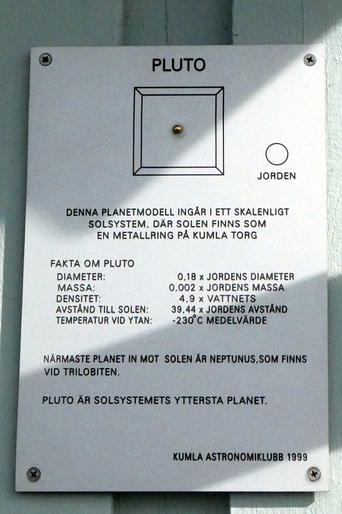
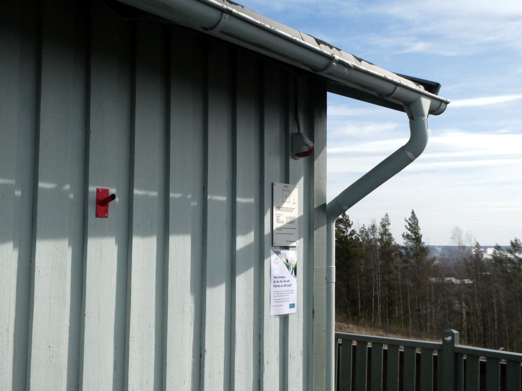
There are some miniature solar systems in Sweden - in 2021 I came upon Pluto at Kvarntorp , belonging to scale solar system the Astronomy Club in Kumla, 12 km away, had set up. (Note that, at that scale, Pluto is about as small as the screws holding the plaque up. And the plaque itself isn't easy to find either, being attached on the side of a building.
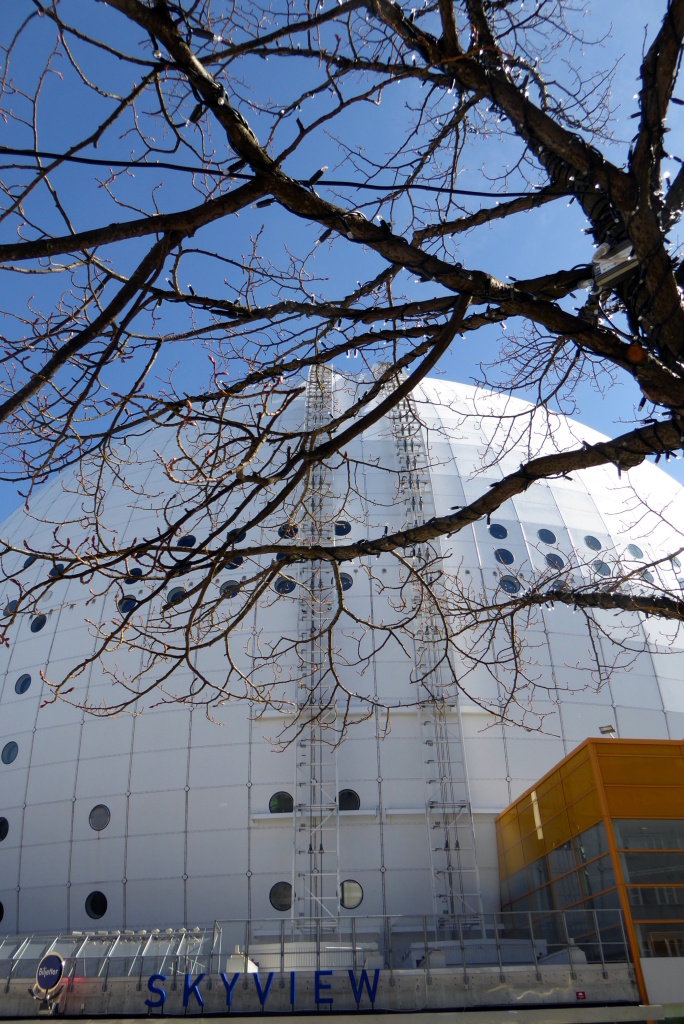
But the Sweden Solar System that starts in Stockholm is designed on a much larger scale.
Instead of using a 'mere' two-meter ball as the sun, they use a large spherical building as their reference point. The building used to be called "Globen" (globe), but it is currently the "Avicii Arena" (which is, oddly enough, not named after a company that purchased the naming rights, but after a Swedish DJ, who died in 2018).
With a diameter of 110 meters, this provides decent sizes for most of the planets. So Earth has 65 centimeter diameter, Jupiter is more than seven meters across and even Pluto with 12 centimeters has a reasonable size. (And the scale does allow a number of objects to be presented that usually don't make it into scale models, as they would be too small. So Eris, Sedna and Makemake are also represented and even some of the asteroids in the asteroid belt, as well as some comets, such as Halley's Comet. (Even at that giant scale, some of the objects have rather small representations, with the asteroid Nut 0.2 mm wide and hardly visible with the naked eye.)
The downside of this scale is, of course, that distances are enormous. Jupiter is 'only' 40 km from Stockholm, but visiting Neptune requires a 300 km drive.
If you want to visit Sedna, a dwarf planet in the outer edges of the solar system, that's more than 700 km from Stockholm. (And that's the designers being nice. And trying to keep the Sweden Solar System in Sweden. Sedna has an highly eccentricity orbit between 11 billion and 140 billion kilometers distance. They selected a value that allowed them to set up the (cool looking) sculpture in Luleå. (I didn't know about that when I visited Luleå in 2021 or I would have visited it.) If they had gone for the maximum distance, the line to the sculpture would have extended past the North Pole and the sculpture would have ended up somewhere Cold Bay, Alaska in the Aleutian Islands.
Coming back to the main point (after that somewhat longish detour) - I had been dimly aware that the largest planet in the solar system, Jupiter, had its representation in the Sweden Solar System scale model somewhere at Stockholm Arlanda Airport. (I think I learned about that when I had been looking up things about the Kumla solar system, after I had found Pluto at Kvarntorp.)
But I had never noticed Jupiter, even though, at the scale used, it had a diameter of more than seven meters.
This year, I had a lot of time at the airport, so I walked around a bit (not actually looking for Jupiter; just being bored).
And suddenly I found an information display, providing information about the Swedish Solar System and Jupiter (and, by the way, the four Galilean moons, which also have information signs at the airport).

So far, so good.
But where was Jupiter?
Even after seeing the sign, it took me quite a while to find Jupiter.
It's more than seven meters across - it can't be that hard to find.
Well...
My erroneous assumption was that I should be looking for a sphere. My other erroneous assumption was that it would be noticeable as a sculpture or some other piece of artwork.
In fact, Jupiter is represented by a ring.

Specifically, the light that illuminates the exit from the 'Sky City' area of the airport towards, among others, the Comfort Hotel across the street.
I did spot the ceiling lights, but I didn't associate that with the solar system model. They looked like regular ceiling lights to me.
And it took a while until I did notice the little sign next to the window on the right, claiming this to represent Jupiter.
So, while not being of any importance at all, I finally found it.
And that's a good point to end this text.
(While a worse point to end this text would be that my luggage got lost on the way back home. I got it the next day, which isn't that bad, especially as I only had to carry my hand luggage home and the heavy bag was brought to me, but it's not as interesting as finding Jupiter at Arlanda airport.)